Eastern Visayas
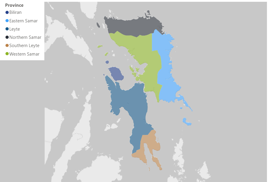
PROFILE
Biliran l Eastern Samar l Leyte l Northern Samar l Southern Leyte l Western Samar
--- EASTERN SAMAR ---
Physical Profile:
Eastern Samar, a province in Eastern Visayas (Region VIII) is bounded on the east by the Pacific Ocean. It has a total land area of 461,720 hectares; roughly 237,785 hectares, or 51.5% of its total land area, are classified as agricultural land.
The province is subdivided into 22 municipalities and one city; twenty of these are located along the coasts, while two are inland municipalities. Its provincial capital, Borongan City, is approximately 550 air-kilometers southeast of Manila, and around 65 air kilometers northeast of its regional capital which is Tacloban City.
The entire area of the province is rough, hilly covered with dense tropical vegetation.
According to Lantican (2001), citing Kintanar (1984) in The Science and Practice of Crop Production, Eastern Samar is classified as Type II, with no dry season and with a very pronounced maximum rain period from December to February. There is not a single dry month. Minimum monthly rainfall occurs during the period from March to May. Since the province faces the Pacific Ocean, it is regularly hit by powerful tropical cyclones such as Typhoon Haiyan.
Agricultural Profile:
The province’s economy is dominated by agriculture and fishing, which are considered as low-income generating activities. A total of 237,785 hectares in the province is devoted to agriculture. About 95% of the total agricultural land or 225,896 hectares are croplands which are composed mostly of commercial crops such as coconut, abaca, banana and pineapple. One fourth of these croplands, or 56,474 hectares, are intended for food crops such as root crops and palay.
Based on the PSA 2018 data, rice is the major crop of Eastern Samar. It has a total production volume of 59,588 metric tons for a harvested area of 22,496 hectares, giving an average yield of 2.65 metric tons per hectare. Following rice as a major crop (rainfed and irrigated palay) are cassava and sweet potato.
For the poultry sector, the province has the highest production of native or improved chicken. On the other hand, for the livestock sector, the province has the highest on swine production. The PSA recorded that the province has produced 111,668 heads of chicken, and 19,210 heads of swine for the year 2019.
--- LEYTE ---
Physical Profile:
The province of Leyte is one of the six provinces of Eastern Visayas Region located in Central Philippines adjacent to Cebu which ranks eight in size among larger islands in the Philippine Archipelago. It lies adjacent to the island of Samar, connected by the San Juanico Strait, and east of the islands of Cebu and Bohol. It is bounded in the north by the Carigara Bay and in the east by the Leyte Gulf. To the west is the Camotes Sea, while the province of Southern Leyte lies south. It is the largest and the oldest province in the Eastern Visayas region comprising approximately 27% or 571,276 hectares of the region’s total land area of 2,143,169 hectare (DENR RFO VIII, 2016). It is composed of forty (40) municipalities and two cities, Ormoc and Baybay, which serve as its commercial centers. It has five (5) congressional districts and has a total of 1,503 barangays.
The terrain of the province is relatively flat to gently rolling and becoming mountainous and rough towards the center where a mountain range begins. This cordillera divides the province into its eastern and western plains. Peaks of approximately 2,295 to 3,280 feet high extend from north to south. The first category is 0 to 3% slope of flatlands covering an area of 173,801 hectares or 30.4% of the total land area. These areas are considered as irrigable and highly suitable for agriculture, urban and industrial uses. The 3% to 8% slope is characterized as gently sloping to undulating and suitable for agricultural and non-agricultural uses. This covers 46,722 hectares or 8.2% of the total land area. The slope between 8% and 18% has a wide variety of uses and suitable areas for planting seasonal and permanent crops. Hilly to mountainous areas which are categorically within the 18% to 30% slope comprise a total land area of 163,220 hectares or 28.6%. Around 30% to 50% slope category is classified as moderately steep to very steep which covers 84,623 hectares or 14.8%. Slope above 50% covering 30,707 hectares is characterized as very steep to extremely rough mountainous areas equivalent to 5.4%.
Leyte has two types of climate. The eastern part has Type II climate characterized by very pronounced rainfall from November to January. The western portion has Type IV climate with rainfall that is more or less distributed throughout the year. Leyte Gulf is affected by both the SE and NE monsoons. As a result, there are no pronounced wet and dry seasons. The NE monsoons nevertheless have a greater effect bringing slightly more rainfall during the months of November, December and January. Compared with other provinces of the country, Leyte has an even and moderate temperature with an average annual maximum of 30°C, minimum of 24°C and an average of 27.3°C.
Agricultural Profile:
Agricultural areas in Eastern Visayas total 976,385 ha in which 34% of this or 332,018 ha constitutes for the agricultural land of the province of Leyte. Of the provinces in the region, it also has the largest croplands, its area planted to crops totaling 322,252 ha or 97% of its total agricultural lands. Leyte also has the most extensive ricelands, which measure 84,277 ha.
On the 2018 PSA Report, the major crops of the province include rice, coconut, and corn. With the volume of production of 486, 878 MT, 94,475 MT, and 48,300 MT, respectively.
For the poultry sector, the province’s focus is on the production of native/improved chicken and duck. On the other hand, for the livestock sector, the province’s focus is on swine and carabao production. The PSA recorded that the province has produced 55,368 heads of chicken, 677 heads of duck, 51,174 heads of swine, and 5,699 heads of carabao for the year 2019.
--- NORTHERN SAMAR ---
Physical Profile:
Part of the Eastern Visayas Region (Region VIII) is Northern Samar. One of the three (3) provinces in Samar Island, it has a total land area of 3,498 square kilometers or 349,800 hectares.
Northern Samar, which is considered a second-class province, is composed of 24 municipalities and 569 barangays; its provincial capital is Catarman.
It has a very rugged terrain with restricted plains and valleys. The river valleys are low-lying and often interrupted by hills. These hills reach their highest elevation at 850 meters in Mt. Capotoan in Palapag. The interior of the mainland consists of highly dissected hills and mountain peaks. Low-lying hills are found between the coastal plains of Palapag, the river valley of Gamay and the Catubig Valley.
According to Lantican (2001), citing Kintanar (1984) in The Science and Practice of Crop Production, Northern Samar’s climate is classified as Type II. this means that it has no dry season and with a very pronounced maximum rain period from December to February. There is not a single dry month and minimum monthly rainfall occurs during the period from March to May.
The province is set near the breeding ground of typhoons, the Philippine Atmospheric, Geophysical and Astronomical Services Administration (PAGASA) has recorded 48 typhoons from 1948 to 2009. The typhoon occurs three times every two years.
Agricultural Profile:
About 69% (243,084 ha) of the province’s land are agricultural areas. In terms of the agricultural area by land use, coconut ranks first with 120,964.90 hectares used as per Philippine Coconut Authority (PCA) report of FY 2014.
Based on PSA (2018), coconut is the major crop produced by the province with a total volume of production of 269,848 metric tons for a harvested area of 84,250 ha, giving an average yield of 3.2MT per hectare. Following coconut as a major crop are palay, sweet potato and banana.
The municipalities of Laoang and Las Navas have the highest volume of rice production, while San Vicente and Biri have the lowest. This is attributed to the presence of water resources, such as beaches and rivers, in lieu of agricultural lands. Most of the municipalities though have adequate areas for rice production. However, some are not blessed with such land resources.
For the poultry sector, native or improved chicken has the highest production, followed by ducks. The PSA recorded that the province has produced 100,105 heads of chicken and 23,550 heads of duck for the year 2019. For the livestock sector, the province has the highest production of swine. The province had produced a total of 9,163 heads of swine for 2019.
--- SOUTHERN LEYTE ---
Physical Profile:
Southern Leyte Province is one of the six provinces in the Eastern Visayas Region, neighboring Leyte Province in the north, facing the Pacific in the east, Camotes Sea in the west and Sogod Gulf in the south.
The province was once a part of Leyte before it was made into a separate province by the year 1960. It is composed of one congressional district, 1 City (Maasin City being its Capital), 18 municipalities. There are 500 barangays, 255 of which are coastal barangays and 245 non-coastal barangays.
Its total land area corresponds to 8.1 percent or 173,480 hectares of the total area of the Eastern Visayas region. The province is composed of a mainland and four islands. The biggest is the Panaon Island that includes the municipalities of Liloan, San Francisco, Pintuyan, and San Ricardo. Followed by the island Municipality of Limasawa, the island barangays of San Pablo and San Pedro of the Municipality of Hinunangan.
The province’s specific climate was obtained from Lantican (2001), citing Kintanar (1984) in The Science and Practice of Crop Production. Whereas, the province of Northern Samar is classified as Type II, with no dry season and with a very pronounced maximum rain period from December to February. There is not a single dry month. Minimum monthly rainfall occurs during the period from March to May.
The province’s native language is a Boholano dialect variant of Cebuano. However, some natives also speak Waray, Filipino (Tagalog), English, and to a much lesser extent, Spanish.
Agricultural Profile:
Southern Leyte is basically an agricultural province complemented by the growth in the services sector. The major sources of income in the province are farming and fishing. The major crops grown are coconut, rice, banana, rice, root crops, fruits, and vegetables. Livestock and poultry are mostly raised in the backyard, and are used for home consumption and special occasions. Carabaos are mostly used in farming and hauling of agricultural products from the farm to the market.
Based on the 2018 data of PSA, Coconut is the major crop of the province with a volume of production of 127,750 metric tons for a harvested area of 32,150 ha giving an average yield of 3.97 MT per hectare. Following coconut as a major crop are rice (rainfed and irrigated palay), white corn and banana.
For the poultry sector, the province’s focus is on the production of native/improved chicken. On the other hand, for the livestock sector, the province’s focus is on swine production. The PSA recorded that the province has produced 1,800 heads of chicken and 6,111 heads of swine for the year 2019.
--- SAMAR ---
Physical Profile:
Samar Island lies Southeast of Luzon. It occupies the Northernmost section of Eastern Visayas (Region VIII). The province of Samar occupies the southwestern part of Samar Island. It has the largest area (559,100 has.) among the three provinces which constitute 42% of the island’s total land area and 26% of Region 8. The San Juanico Bridge connects Samar to the province of Leyte on the southeast across the San Juanico Strait. It is bounded by Northern Samar and Eastern Samar on the North and East, respectively. The provincial capital of the province is Catbalogan and is 107 kilometers from Tacloban City, the regional capital of Eastern Visayas.
Western Samar has two cities and 24 municipalities. It is divided into two districts. The first district consists of Calbayog City, municipalities of Gandara, Matuguinao, San Jorge, Sta. Margarita, Tarangnan, Sto. Niño, Pagsanghan, Tagapul-an and Almagro. On the other hand, the second district is composed of Catbalogan City, municipalities of Basey, Paranas, Hinabangan, San Jose de Buan, Villareal, Sta. Rita, Calbiga, Motiong, Pinabacdao, Daram, Marabut, Jiabong, Zumarraga, Talalora and San Sebastian. The province has a total of 951 barangays.
Western Samar is described as hilly and mountainous ranging from 200 to 800 meters high. Slopes are generally steep and bare of trees. Run-off rainwater on these slopes is substantial and can provoke flooding in lowland areas. Topsoil is carried to the sea, creating hydrosols and enlarging mudflats and mangrove areas. The erosion of mountain areas enlarges the coastal plains of Samar. The coastline is approximately 300 kilometers long, which boosts its rich fishing grounds and contributes much to our economy. Lowlands in Samar can be found in the area of Calbayog and on the deltas and small valleys of Gandara and Ulot rivers. Slopes are generally steep and bare of trees due to deforestation and “kaingin”. Run-off waters after heavy rains can provoke flooding in low-lying areas. It can also cause erosion of the mountain land, which affects coastal plains of the province.
The province falls under type II and IV climate. Type II is characterized by having no dry season with a very pronounced maximum rain period from December to February. Minimum monthly rainfall occurs during the March to May period. Areas characterized by this climate are generally along or very near the eastern coast, thus, open to the northeast monsoon. Municipalities in the southeastern part of the province experience this type of climate. Type IV climate has no maximum rain and no dry season (rainfall is more or less distributed throughout the year). This is an intermediate between the first and second types of climate, although it resembles the second type more closely, hence it has no dry season. The areas located at the Northwestern part of the province have this type of climate, and that includes the municipalities of Gandara, San Jorge, Pagsanghan, Tarangnan, Sta. Margarita, Sto. Niño, Almagro, Tagapul-an, Calbayog City and portions of Matuguinao and San Jose de Buan.
Western Samar has four main groups of soils covering 559,100 hectares, namely; soils at the Eastern portion of the province, soils at the central section, soils at the Northwestern portion, and soils in the Southwestern portion. The second group found in the central section of the province holds about 112,098.5 hectares. The soil typed predominating in this area is clay loam. The third soil group, which is the largest in terms of area, has about 234,092 hectares. Under this group, the Catbalogan clay loam is agriculturally the most vital soil type representing about 34% of the total area. The Tingib clay loam, Dolongan loamy sand, San Miguel clay loam, Biga-a clay loam, and Hydrosol make up the rest of the province’s soil cover. Most of these are found on plains and along the valleys where most of the agricultural crops are grown.
Approximately 62,663 hectares make up the fourth soil group. About 33,060 hectares are found in the municipalities of Villareal, Catbalogan and the island municipalities of Zumarraga and Daram. The rest are found in the southern tip of the province.
Agricultural Profile:
The total agricultural land in the province constitutes about 18% or 101,954 hectares of its total land area. Western Samar is rich in agricultural crops. Based on the Department of Agriculture (DA) – Adaptation and Mitigation Initiative on Agriculture’s (AMIA) Farmers’ Guide Map, crops suitable for the province are abaca, banana, cacao, cassava, coconut, corn, legumes, oil palm, papaya, pineapple, rice, rubber, sugarcane, sweet potato, taro, vegetables and yam. However, the champion commodity in the province is coconut and rice. The total volume of production for rice in 2018 is 13151,567 metric tons. Meanwhile for the coconut, the total volume of production is 272,617 metric tons.
The poultry and livestock industry in the province which includes chicken, swine and carabao have the largest number in terms of inventory. The PSA recorded that the province has produced 3,051 heads of chicken, 6,025 heads of swine, and 1,795 heads of carabao for the year 2019
The people of Western Samar rely on the following agri and fishery related livelihood industries:
- Integrated Mussel Industry (Calbayog);
- Coco Oil Industry (Calbayog);
- Tinapa Industry (Calbayog);
- Native Cheese Processing (Gandara);
- Abaca Industry;
- Ticog Industry (Basey);
- Fishing Industry; and
- Copra Industry.
AGRICULTURAL PRODUCTION ACCOUNTS
Source: Philippine Statistics Authority
B. Value of Production in Agriculture at Current Prices, Eastern Visayas, 2018 to 2020
C. Percentage Distribution of Value of Production in Agriculture, Eastern Visayas, 2018 to 2020
D. Volume of Production in Agriculture, Eastern Visayas, 2018 to 2020
E. Average Farmgate Prices in Agriculture, Eastern Visayas, 2018 to 2020