Bicol Region
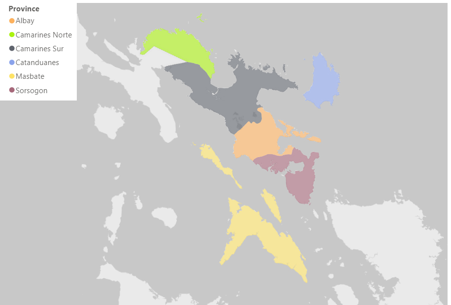
PROFILE
Albay l Camarines Norte l Camarines Sur l Catanduanes l Masbate l Sorsogon
--- CATANDUANES ---
Physical Profile:
The island province of Catanduanes is a kidney-shaped island at the easternmost seaboard of the Philippines. It is the first landmass of the Philippine archipelago to kiss the Pacific Ocean. As part of Bicol Region, Catanduanes is the 12th largest island of the Philippines with a total land area of 151,150 ha.
The province is a lush island of mountains and water. Forest cover is about 46% of the total land area. Surfacing from the mountains are numerous springs, waterfalls, and rivers trailing out into the ocean. The island is lined with more than 20 islets and rocks that give it an interesting shoreline.
The topography of the province is rugged and mountainous. Only about 10% of the land area has slope gradients under 8%.
It is a lone district, consisting of 11 municipalities, which are Bagamanoc, Baras, Bato, Caramoran, Gigmoto, Pandan, Panganiban, San Andres, San Miguel, Viga, and Virac.
Agricultural Profile:
Catanduanes has a total land area of 149,216 hectares, of which 47,901 hectares were use in farming. The major crops of the province are abaca, coconut, rice, peanut, and lowland vegetables. The Philippine Fiber Development Authority declared Catanduanes as the highest abaca-producing province in 2010. It has maintained its “abaca country” status as the top abaca fiber-producing province in the Philippines.
In 2015 alone, the island’s 12,789 abaca farmers produced 23,550 metric tons of raw fiber, comprising 40% of the total abaca fiber production nationwide. The local fiber harvest is even higher than the production of Ecuador, the second-biggest abaca producer in the world after the Philippines.
As of 2019, PSA reported that swine has the highest livestock inventory at 73,608 while native chicken has the most number in the poultry industry with 60,700.
--- MASBATE ---
Physical Profile:
The province of Masbate is a coastal province which occupies the southeastern peninsula of Luzon. Its three major islands are Masbate, Ticao, and Burias. It has 20 municipalities, a capital city, and 550 barangays with a total land area of 404,770 ha. Based from the 2015 census, the province has a population of 892,393.
Masbate has vast grazing lands favorable for raising small and large ruminants like goats and cattle. It is characterized by rolling hills and discontinuous ranges of highlands and relatively broad bands of lowlands. Mt. Bagasimbahan is the island’s highest elevation (Masbate-Baleno-Aroroy) with an altitude of 697 meters. On its northwestern tip are limestone cliffs which rise almost perpendicularly from the waterline and has several bays indent to the coast of the island.
The province is also known as the Rodeo Capital of the Philippines. It has a mixture of Bicolano and Visayan cultures. Most of people in Masbate speaks Masbateno which is a Bisakol blend of Bikol, Capiznon, Cebuano, Hiligaynon, Waray-Waray, Romblomanon, and Tagalog. Other languages spoken in the island are Bikol, Tagalog, Cebuano, and English.
Agricultural Profile:
Farming is the main source of livelihood in the province of Masbate. According to PSA in 2015, the province ranked second in terms of farm area in the Bicol region with a total of 207,500 hectares in 59,353 farms.
Coconut, rice, corn, cassava, sweet potato, and mango are the major agricultural crops grown in the province. Rice is the highest in terms of volume of production with 156,032 mt while cassava topped in terms of yield at 7.23 mt/ha.
For livestock inventory in 2019, swine has the highest number at 114,786. For poultry, native chicken has 1,097,597 heads.
--- SORSOGON ---
Physical Profile:
Sorsogon province is known to be at the southern tip of Luzon or the tip of Bicol peninsula and faces the island of Samar to the southeast across the San Bernardino strait and Ticao Island to the southwest. It is composed of two districts and subdivided into 14 municipalities and a capital city. Except for landlocked Irosin, all the towns rest along the coast.
The province has a total land area of 214,140 hectares (has) with a terrain of rolling hills and mountains with coastal lowlands. As of 2015 census, its total population was 792,949.
People in Sorsogon are migrants from Visayas, such as Warays and Hiligaynons but Bicolanos remain the dominant cultural group. Sorsogueños is the local name for the people of Sorsogon and they can communicate in different dialects such as Bikol, Sorsoganon, Tagalog, and English.
Agricultural Profile:
Sorsogon is primarily an agricultural province where rice is the major temporary crop while coconut and pili remain the major permanent crops. Other major temporary crops are corn and bananas.
The province has a total agricultural land area of 126,594 has. Temporary crop land is 18,547 ha and permanent crop land is 104,597 ha, where the majority is planted with Pili trees.
Native chicken and swine have the most number of inventory for the poultry and livestock industries in the province with 755,000 and 94,466 count, respectively, in 2019.
AGRICULTURAL PRODUCTION ACCOUNTS
Source: Philippine Statistics Authority
B. Value of Production in Agriculture at Current Prices, Bicol Region, 2018 to 2020
C. Percentage Distribution of Value of Production in Agriculture, Bicol Region, 2018 to 2020
D. Volume of Production in Agriculture, Bicol Region, 2018 to 2020
E. Average Farmgate Prices in Agriculture, Bicol Region, 2018 to 2020